


GPSmyCity: Walks in 1K+ Cities
4.3468.00 Reviews
App Specs
- Version
- 3.7.5
- Updated On
- License
- Free
- Downloads
- 500,000+
- Developer
- GPSmyCity.com, Inc.
- Categories
- Travel & Local
- Platform
- Android, iOS
Screenshots
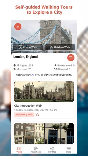
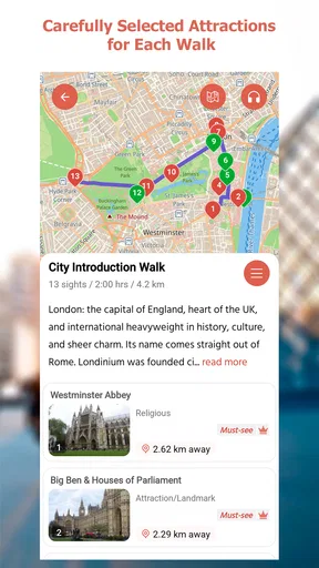
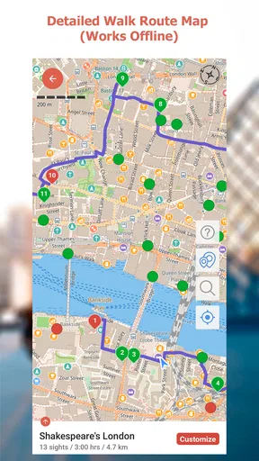
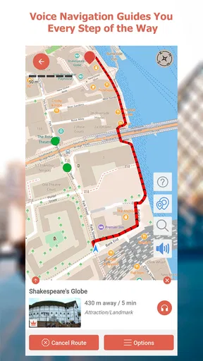


 Analysis by AppCompare
When I decide how to explore a city, I first ask whether I want a fixed group tour, a map to improvise with, or a route I can follow at my own pace. GPSmyCity: Walks in 1K+ Cities is aimed at that middle ground: it gives a walk structure without asking me to keep up with a guide or plan every stop from scratch. That makes it especially useful when I have a free afternoon, want to see a neighborhood on foot, and would rather not spend half the time searching for ideas.
It is a free travel and local app from GPSmyCity.com, Inc., with optional in-app purchases ranging from $1.99 to $20.99 per item. I’d think of the free download as a way to see whether its city-walk approach suits me, then check the specific access and purchase options for the places I plan to visit. The app is rated for Everyone, has a 4.3 average from around 2.8K ratings, and has passed 500K installs. Those figures suggest a well-used option, but they don’t tell me whether a particular walk fits my pace or interests; that is the decision I’d make before relying on it for a whole day.
Choose it for a walk, not as your whole trip planner
The app’s clearest role is helping turn sightseeing into a route on foot. That is different from using a general map to get from one address to another: a map is flexible and practical for navigation, while a self-guided walk gives the outing a more intentional shape. I would use GPSmyCity when I want to connect places and learn a little as I go, and keep a regular map handy for transit, restaurant searches, or a sudden change of plan.
It is a good fit for independent travelers who like having a suggested direction but don’t want a scheduled group. It can also help a local looking for a reason to explore a familiar area with fresh eyes. On the other hand, if I’m mainly trying to find the fastest route across town, need detailed live transport planning, or want a guide to answer questions in person, I’d choose a different kind of tool or experience.
Exploring the World One City at a Time
The beauty of GPSmyCity lies in its simplicity and vast coverage. Over 1,000 cities are waiting for you to explore through self-guided walking tours. Whether you’re in bustling New York City or a quaint European village, the app offers something for everyone. What I love is that you don’t need an internet connection to navigate once you've downloaded a city. This means no hefty roaming charges when you're abroad. Sweet, right?
Offline access is most valuable when I prepare before leaving my accommodation rather than assume everything will be ready once I’m outside. I’d look up the city and walk I’m interested in, download what I need while connected, and open it once before setting off. That simple check helps avoid discovering at a street corner that I haven’t saved the material I expected to use. Offline navigation also makes the app a sensible backup for a day when mobile service is unreliable, though it doesn’t remove the need to pay attention to the street, local signs, or changing access conditions.
Features That Stand Out
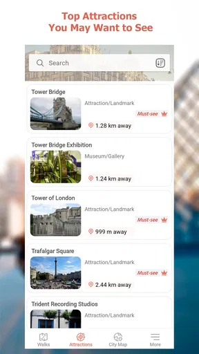
One of the coolest features is the offline navigation. You can download the city maps and guides, which is a lifesaver when you're lost in a foreign place with no Wi-Fi in sight. The app also provides detailed information about each site, so you can look like the history buff you’ve always wanted to be.
Worth Reading Before You Choose

Flipboard Shows What News Apps Must Do Beyond the Feed

Switching to Android Auto Means Rethinking Your Driving Routine

Google Calendar Makes a Crowded Week Easier to Manage

Ludo King Makes the Most of the Minutes Between Plans

Baby Panda World Brings Quick Play to Modern Phones, but Its Game Library Feels Busy

ESPN’s Live Game View Makes Following Close Games Easier
The descriptions make a walk feel more rewarding when I pause at a building or landmark and want context beyond its name. I’d treat them as short companions to looking around, not as a substitute for a museum visit or a specialist history source. A practical way to use them is to read a stop’s information while standing safely to one side, then put the phone away and take in the place. That keeps the outing from becoming a screen-led checklist.
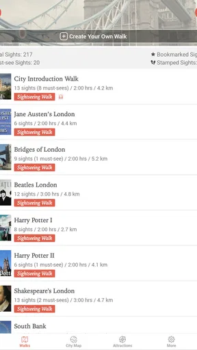
Customization is another strong suit. You can create your own walking tours by selecting the places you want to visit. It’s kind of like being your own tour guide, without the pressure of getting lost. Plus, the app suggests routes based on your preferences and even tracks your progress. It’s like having your very own travel assistant.
That flexibility matters most when a standard walk is close to what I want but not quite right. I might remove a stop that doesn’t interest me, prioritize a landmark a friend recommended, or leave room for a coffee break. Before committing, I’d still consider the distance and the energy of my group: a route that looks manageable on a map can feel different in heat, rain, or with a child who needs frequent pauses. Customizing a walk is useful precisely because a travel day rarely goes exactly to plan.
The User Experience
Let’s talk about usability. The interface is clean and intuitive, which makes planning your day a breeze. Even if you aren’t tech-savvy, you’ll find it easy to navigate. The app is available on both Android and iOS, ensuring that no one misses out on the adventure.
GPSmyCity was released on May 22, 2017, and its current version is 3.6.6, with Android support beginning at OS 10. I’d check that requirement before planning around the app on an older Android phone. Its straightforward purpose is an advantage: I don’t need to treat it like a full travel dashboard. Still, people who prefer to do all planning in one place may find switching between a walking-tour app, a general map, and other travel tools less convenient.
For a realistic use case, imagine arriving in a city with one open afternoon and no appetite for a tightly scheduled tour. I’d choose a walk near where I’m staying, download its material over Wi-Fi, and start after lunch. If a stop catches my interest, I can linger; if the weather turns or my feet get tired, I can shorten the plan instead of feeling obliged to finish every point. The app gives that outing a starting structure, while the decision to pause or change direction stays mine.
One trade-off to keep in mind is that offline maps and guides solve a connectivity problem, not every travel problem. They don’t make a route suitable for every mobility need, guarantee that a site is open, or tell me whether a street feels comfortable at a particular time. I’d use the walk as a guide rather than an instruction to follow blindly, checking local conditions and choosing safe crossings. Travelers who need accessibility details or current opening information should verify those separately before setting out.
Why It’s Worth a Download
So, why should you download this app? Well, if you’re a travel enthusiast, or simply someone who loves exploring new places, GPSmyCity is a must-have. It’s perfect for solo travelers, families, or even locals looking to discover hidden gems in their own city.
I’d be more cautious about recommending it to someone who dislikes walking, wants a live human guide, or expects one app to handle bookings, public transport, and every practical detail of a trip. A general navigation app is the better everyday choice for direct directions and spontaneous errands; a guided tour suits travelers who value conversation and a fixed itinerary. GPSmyCity occupies a narrower but worthwhile space between those options: an independent walk with information along the way.
The purchase model is worth checking before you build a trip around a particular route. The app itself is free, but optional items have different prices, so I wouldn’t assume every city or walk is included at no cost. I’d browse the destination and confirm what I can access before traveling. That small bit of preparation is more useful than downloading the app at the last minute and discovering that the specific content I hoped to use requires a purchase.
For a weekend away, I’d use it selectively rather than plan every day around it. One walk can give a new neighborhood a useful starting point; the rest of the trip can remain open for markets, meals, museums, and unexpected detours. This approach also makes it easier to judge whether the walking format works for me before buying additional content. If I’m traveling with others, I’d agree on a rough route together first, since even a flexible guide won’t resolve different preferences about pace or stops.
What should I do before relying on a walk? I’d download the relevant material while connected, review the route, and leave enough time to stop and read. Can I use it without mobile data? Offline navigation is available after downloading the city maps and guides, so preparation is the key. Is it right for a short visit? It can be, provided I choose a walk that fits the time I have rather than trying to cover too much. And if my priority is live local conversation or transport directions, I’d pair it with another option instead of expecting a self-guided walk to do both jobs.
What I appreciate is the attention to detail in the descriptions and historical context provided for each location. It’s like having a mini history lesson without the snooze factor. You get to learn about the culture, architecture, and stories that make each city unique.
Wrapping It Up
In a nutshell, GPSmyCity: Walks in 1K+ Cities offers a unique blend of convenience, education, and fun. It’s like embarking on a treasure hunt where every destination has a story waiting to be discovered. So, whether you’re a seasoned traveler or someone just starting their journey, this app is a valuable addition to your travel toolkit.
Ready to explore the world one city at a time? Grab your phone, download the app, and let the adventures begin!
My recommendation is to try it when the goal is a thoughtful city walk, especially if I want independence, context, and the option to go offline after preparing. I wouldn’t treat it as a replacement for a map, a live tour, or careful checking of local conditions. Used for what it does best, it can turn an unplanned stretch of free time into a more purposeful outing without taking away the freedom to wander.
Pros
- Wide variety of city guides available.
- Offline access for convenience.
- User-friendly interface.
- Detailed maps with landmarks.
- Customizable walking routes.
Cons
- Limited free content options.
- Occasional GPS inaccuracies.
- Premium features are costly.
- No real-time traffic updates.
- Some cities lack detailed guides.
FAQs for GPSmyCity: Walks in 1K+ Cities
What is GPSmyCity: Walks in 1K+ Cities?
GPSmyCity: Walks in 1K+ Cities is a travel app that provides self-guided walking tours in over 1,000 cities worldwide. The app allows users to explore cities at their own pace, offering detailed maps and points of interest without needing an internet connection. It's perfect for travelers who enjoy discovering new places independently.
How does GPSmyCity work offline?
GPSmyCity offers offline functionality by allowing users to download maps and guides before they travel. Once downloaded, these resources can be accessed without an internet connection, ensuring that users can explore and navigate cities without worrying about roaming charges or connectivity issues.
Is there a cost to use GPSmyCity?
The app itself is free to download, and users can access basic features at no cost. However, specific city guides and tours might require an in-app purchase. There are also subscription options available for users who wish to access all premium content across multiple cities.
What are the main features of GPSmyCity?
GPSmyCity provides a range of features including detailed offline city maps, self-guided walking tours, and descriptions of points of interest. The app also offers GPS tracking to help users navigate efficiently. Users can customize their tours by selecting preferred attractions and receive notifications about significant landmarks nearby.
Can GPSmyCity be used for all types of travelers?
Yes, GPSmyCity is suitable for a variety of travelers, including solo adventurers, couples, and families. It caters to those who prefer self-guided experiences, offering flexibility to explore at one’s own pace. Whether you’re on a short visit or an extended stay, the app provides comprehensive resources to enhance your trip.


